Identifying the use of a park based on clusters of visitors' movements from mobile phone data
Keywords:
clustering, human behavior analysis, public open spaces, ICT, landscape planningAbstract
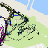
Planning urban parks is a burdensome task, requiring knowledge of countless variables that are impossible to consider all at the same time. One of these variables is the set of people who use the parks. Despite information and communication technologies being a valuable source of data, a standardized method which enables landscape planners to use such information to design urban parks is still broadly missing. The objective of this study is to design an approach that can identify how an urban green park is used by its visitors in order to provide planners and the managing authorities with a standardized method. The investigation was conducted by exploiting tracking data from an existing mobile application developed for Cardeto Park, an urban green area in the heart of the old town of Ancona, Italy. A trajectory clustering algorithm is used to infer the most common trajectories of visitors, exploiting global positioning system and sensor-based tracks. The data used are made publicly available in an open dataset, which is the first one based on real data in this field. On the basis of these user-generated data, the proposed data-driven approach can determine the mission of the park by processing visitors' trajectories whilst using a mobile application specifically designed for this purpose. The reliability of the clustering method has also been confirmed by an additional statistical analysis. This investigation reveals other important user behavioral patterns or trends.
Downloads
Published
Issue
Section
License
Copyright (c) 2019 Roberto Pierdicca, Marina Paolanti, Raffaele Vaira, Ernesto Marcheggiani, Eva Savina Malinverni, Emanuele Frontoni

This work is licensed under a Creative Commons Attribution 4.0 International License.
Articles in JOSIS are licensed under a Creative Commons Attribution 3.0 License.
